A tale of two droughts in California: Wetter in the north, still bone dry in the south

The first place officials look to assess the drought is the northern Sierra Nevada.
- Share via
When California water officials assess the drought, the first place they look is the northern Sierra Nevada mountains.
Rain and snowmelt from the area feed into a complex system of rivers, canals and reservoirs that send water across the state. And by almost all measures, the drought picture in Northern California has dramatically improved over the last two months, as a series of storms have helped replenish the state’s two major water projects. So far this season, rain levels in the northern Sierra are 180% of average, with 23.5 inches of rain falling — and more on the way this week.
But the story is more grim in Southern California, which remains historically dry. Now water officials must figure out how to deal with the disparity and its implications for managing the drought. While Southern California still gets some water from the Sierra, about 50% of its supply comes from local sources such as groundwater and reservoirs.
“California is a big place. It has different droughts in different parts,” said Jay Lund, a professor of civil and environmental engineering at UC Davis who studies water in California. “We certainly saw that last year … and we’re likely to see that again.”
Another big storm moving into California on Thursday is expected to dump large amounts of rain and snow in the north and considerably smaller amounts in Southern California.
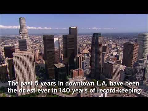
Los Angeles marked a sober milestone earlier this year, when the National Weather Service announced that the last five years were the driest ever documented in downtown L.A. since official record keeping began almost 140 years ago. Precipitation during that period totaled just 38.79 inches — roughly half of normal.
Forecasters had predicted a wet 2016 fueled by El Niño, but the big storms never materialized. Federal climate scientists declared La Niña conditions last month, which they said will likely keep Southern California dry again this winter.
Northern California typically gets more rain than Southern California does, and the state’s water system is designed with that in mind; it moves water from the Sierra into cities and farms to the south.
But Lund said that even as conditions have gotten wetter, the state has struggled to move surplus water south across the delta. As a result, the benefits have been limited.
The sixth year of California’s drought could hardly have gotten off to a better start in Northern California. In October, when the water year began, the northern Sierra got more than four times its average amount of precipitation for the month.
As recently as last week, the northern Sierra got another 8 inches of precipitation, said Idamis Del Valle, a meteorologist with the National Weather Service office in Sacramento.
Forecasters say two more storm systems — the second of which will strike Los Angeles — will collectively dump as many as 9 additional inches of rain on the area by Friday.
“Here in Northern California, there has been some improvement,” Del Valle acknowledged.
The recent rains were enough to force federal officials to begin releasing water from Folsom Lake to protect against flooding for the first time since March, said Louis Moore, a spokesman for the Bureau of Reclamation, which manages the reservoir. Since the beginning of December, Folsom has risen more than 20 feet — an increase of about 55 billion gallons.
As of last week, the U.S. Drought Monitor reported that drought conditions no longer apply to about 27% of California; it should come as no surprise that all the areas where the drought has relented are located in the upper reaches of the state.
Meanwhile, a vast swath of Southern and Central California — from Orange County to Tulare County — remains mired in “exceptional” drought conditions, according to federal officials.
The so-called Key Well, which measures groundwater levels in the San Gabriel Basin, hit a historic low in October. Meanwhile, Lake Perris in Riverside County is holding less than half the amount of water it usually does at this time of year. Castaic Lake in Los Angeles County is faring only marginally better, filled to only 74% of its normal levels.
Along the Central Coast, Lake Cachuma is filled to only about 7% of its capacity, which has prompted Santa Barbara city officials to impose a ban on lawn watering, effective next year. Further inland, the Tulare Basin has received only about four inches of rain so far this water year — about 64% of average.
“We have some systems that are back in their normal operating range,” said State Climatologist Mike Anderson, “and we have other areas that are in the thick of things as much as they’ve ever been.”
Thursday’s winter storm is expected to cover the entirely of California, Anderson said. But it could be particularly helpful to the southern parts of the state that need the rain the most.
Since Oct. 1, Los Angeles County has gotten about 70% to 90% of average rainfall, said Jayme Laber, a hydrologist in the National Weather Service’s Oxnard office. For example, about 1.4 inches of precipitation has fallen on downtown L.A. since that time — about an inch less than normal.
Thursday’s storm alone could add more than an inch of rain to downtown and fill the gap, Laber said. But it is unlikely to generate the type of torrential rain that causes flooding.
If we can get a couple these types of storms back to back to back, that would really help us out.
— Jayme Laber, National Weather Service hydrologist
“If we can get a couple these types of storms back to back to back, that would really help us out,” Laber said.
Angelenos should expect the rain to start falling Thursday around 6 p.m. and stop by Friday afternoon, Laber said. Forecasters expect the coast and valleys to get as much as an inch of rain, while the foothills and mountains could see as much as three or even four times that amount.
Winds will increase in strength after rain passes through, and motorists heading toward the Grapevine should expect to see a “dusting” of snow on the roadway, Laber said. But fortunately, he added, “the heaviest part of the rain will be when most people are sleeping.”
Lots more snow could fall in Northern California, where the storm is expected to drop powder below pass levels. Several Northern California passes could see between 12 and 24 inches of snow, creating white-out conditions and travel delays, Del Valle said
While that’s bad news for drivers, it’s good news for the state; hydrologists are already concerned about the subpar state snowpack developing so far this water year. As of Wednesday, the snowpack stood at only about 57% of normal for the date.
Officials are watching snowpack carefully because snowmelt is what gradually feeds the state’s reservoirs during the hot summer months.
The storms so far this winter have been warm, said Doug Carlson, a spokesman with the state Department of Water Resources. And when so much water falls as rain, officials often must release some of it, as they are currently doing at Lake Folsom.
Experts are quick to note that even after all the Northern California rain, the state’s major reservoirs are filled to only 90% of average for this time of year.
“This is a good chance to start to turn the tide a little bit,” Anderson said. “This is when we want to see our winter storms come in, and the fact we’re seeing that here is a good sign.”
“It’s nice,” he added, “that winter is actually behaving like winter.”
Twitter: @ByMattStevens
ALSO
Phone records and reporter’s testimony put ex-L.A. County sheriff inside obstruction of FBI probe
Heavy rains to arrive Thursday; mud flows are a concern for Southern California foothills
Ex-owner of dog that had 42-pound tumor is charged with animal cruelty
More to Read
Sign up for Essential California
The most important California stories and recommendations in your inbox every morning.
You may occasionally receive promotional content from the Los Angeles Times.


